.JPG)
.JPG) We
drove down Maryland 133 to Pokimoke River State Park, a park and campground next
to the Pokimoke river and a cypress marsh. We enjoyed the nature hike, and are
thinking about getting a 2-man kayak tomorrow to go through the cypress creek…
We
drove down Maryland 133 to Pokimoke River State Park, a park and campground next
to the Pokimoke river and a cypress marsh. We enjoyed the nature hike, and are
thinking about getting a 2-man kayak tomorrow to go through the cypress creek…
September '07 - Page 6
| Previous Page | INDEX | Next Page |
Friday, Sept. 21
We had so much fun at Assateague, that we tried hard to get a second night there at the campground, but they were all booked for the weekend, and even though we asked 3 times this morning if there were any cancellations, we had to move (you can’t stay in a National or State Park overnight in any place except a campground). So plan B: we took additional walks and saw two interesting videos at the Visitor Center.
We
drove down Maryland 133 to Pokimoke River State Park, a park and campground next
to the Pokimoke river and a cypress marsh. We enjoyed the nature hike, and are
thinking about getting a 2-man kayak tomorrow to go through the cypress creek…
Saturday, Sept. 22
The two-man kayak day it was! It took about one hour to go through the cypress creek around the Pokemoke river and back again. A few birds, even an osprey, a snake swimming in the water and a few others, but the trip was very enjoyable none the less.
 It is very
hot (>90 degrees), so we decided to make this a drive day to someplace cooler.
We drove south on 113 and 13 through and over the Chesapeake Bridge and Tunnel.
The whole is 17.3 miles long, with two sections of tunnel, each one mile long.
Very impressive; we felt we were crossing the ocean!
It is very
hot (>90 degrees), so we decided to make this a drive day to someplace cooler.
We drove south on 113 and 13 through and over the Chesapeake Bridge and Tunnel.
The whole is 17.3 miles long, with two sections of tunnel, each one mile long.
Very impressive; we felt we were crossing the ocean!
Heading west through the state of Virginia on Hwy 58, we passed many small towns and some water, and loved the hilly country. Hwy 58 is 4-lane much of the way. We had planned to drive all the way to a Corps of Engineers campground, just north of Martinsville but lost on the directions, and got caught on a road that had an overpass with 11 feet 1 inch clearance. That is lower than our camper, so in backtracking we happened to come upon, guess what? A super Wal-Mart! We spent the night there. God is good!
Sunday, Sept. 23
We are just a half hour south of Roanoke and where Hwy 220 comes across the Blue Ridge Parkway. Patty reminded that there was a Virginia Explore Park near there that we just missed on our last trip up the Parkway because we had arrived on a day it was closed. Today it was open in the afternoon. The park is a history park with reconstructions of 1700’s and 1800’s life in the area. The exhibits were very good, as were the interpreters. We learned a lot about the local history and the role of this part of Virginia in the larger picture.
.JPG)
.JPG)
.JPG)
.JPG)
.JPG)
a.jpg)
This was an interesting historical document quoting our nation's fathers about God and our nation.
b.jpg)
c.jpg)
We camped in the Roanoke Mountain campground, same place as last year, and found again that there was to be a free concert in the campground at 5 p.m. We arrived late, but saw and heard some of it! Maybe next time, we will get it all straight!
Monday, Sept. 24
Starting
today, we had to hustle a little bit to get to San Antonio by Friday afternoon.
This doesn’t mean that we take the Interstate, though, but find some back roads
going west then south towards the Lone Star state, all the while trying to find
some government campgrounds. With the “geezer pass”, Golden Age passport, we
get to camp for half price! So, if you can follow, here are the roads we took: .JPG) 420W
through Virginia, to 83W to 119W to 15N to Littcarr Corps of Engineers
campground.
420W
through Virginia, to 83W to 119W to 15N to Littcarr Corps of Engineers
campground..JPG)
Start of autumn color.
Tuesday, Sept. 25
Today, we decided to take the back roads west in Kentucky to the Barren River Lake Corps of Engineers Campground where we were last year. To do this, see if you can follow with a map of Kentucky:
160W to 15N to 451W to 80N to 421W to 118N to Cumberland Parkway W (exit 44 to 20) to 80N to 192W to 80W to 27S to 90W to Parkway W to 31E W to 252N to 517N to Barren River Lake Corps of Engineers Campground.
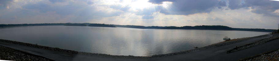
.JPG)
This is one of our favorite Corps of engineers campground. You can see why.
That's our camper by the side of the lake.
Wednesday, Sept. 26
.jpg)
.jpg) Same today. We decided to head down the Natchez Trace Parkway, but start
somewhere south of Nashville at the point where we headed north the last time we
were on the Parkway. This meant a good stretch of Interstate 65 from Kentucky
to the Parkway.
Same today. We decided to head down the Natchez Trace Parkway, but start
somewhere south of Nashville at the point where we headed north the last time we
were on the Parkway. This meant a good stretch of Interstate 65 from Kentucky
to the Parkway.
The Natchez Trace is a great road, a pleasant drive if you are not in a hurry.
Route we took today: 252S to 31E S to 100W to I65 to 412W to 43S to 64W to Naches Trace Parkway mile 370 to mile 243 to Davis Lake Forest Service campground.
Thursday, Sept.27
.JPG)
.JPG)
From the campground, we drove down from mile 243 to mile 0 at Natchez, stopping at French Camp (left), then continued wets across Louisiana to the ssam Rayburn Lake COE campground in Texas.
A busy day driving with apparently not much time taking pictures.
Friday, Sept.28
Drove across
Texas to San Antonio to Derek and Verr's place for Derek's surprise birthday
party..JPG)
He was surprised!
| Previous Page | INDEX | Next Page |